
Solo Road Trip: ID/WY/MT National Parks
DAY ONE - Craters of the Moon
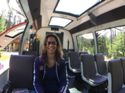
The morning of August 19, I got into my rental car to begin my second solo road trip since being confined to a scooter or power wheelchair full-time—and actually, since my MS diagnosis in 2005. You may have read my blog posts from my Canyonlands trip back in November 2015; that was an adventure I’ll never forget, and didn’t think I could ever duplicate. But here I am trying! The different with this trip is that I’m more anxious (and more than a bit scared) about dealing with breaking apart my scooter and putting it into and taking it out of the rental car trunk. This concern was exacerbated by the fact I haven’t been walking at all since I got my accessible Ford Explorer MXV in late May. To make myself feel more secure in the short hobble between the driver’s seat and the trunk, I bought a very lightweight folding walker in Boise, and that has made a huge difference.
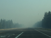
Okay! I’m in the car. I have my walker in the front seat, my GPS, my SPOT GPS emergency beacon, two bottles of water, snacks, my phone charger, and selfie stick/monopod. Time to roll! My first objective would be Craters of the Moon National Monument, about three hours to the east of Boise. The drive was mostly uneventful; a few golden hills here and there, many treeless plains, a few foothills off in the distance, and an ever-present low amber haze—a byproduct of forest fires.
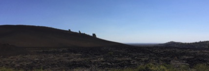
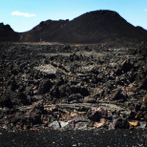
As I approached CotM, I could tell I was getting close by the black rocky mounds all along the roadside. CotM is a huge lava formation that wasn’t even considered a notable discovery until the 1930s. It was created by lava seeping up through fissures in the earth and through “splatter cones,” where lava would literally splatter out of small volcanic cones. Much of the park basically looks like 75,000 dump trucks came in and unloaded millions of tons of coal every day for a year. In addition to the rocky formations, there are hills made of black sand, much like in Hawaii. But the landscape isn’t lifeless; there are white lichens and flowers growing everywhere, as well as sagebrush and other greenery. Honestly, it’s the most bizarre place I’ve ever seen in my life—and that’s saying something.
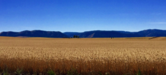
After CotM, I had to drive another 3 ½ hours or so to my next hotel in Victor, Idaho. This second half of the drive was far more interesting than the first half. The landscape was more diverse, partly because I saw a wheat field for the very first time! I have been to roughly 35 US states, and while I’ve seen WAY more than my fair share of corn, I have never seen a wheat field. And apparently Fridays are watering days for every farm in east Idaho; every ginormous irrigation rig in the state must have been spraying, from what I saw. And then there was the harvesting absolutely everywhere! This may not sound like a big deal to many of you, but watching a huge combine harvesting wheat is something I consider to be so American (yes, I know wheat is grown in other countries)—blame it on all those EPCOT movies in The Land.
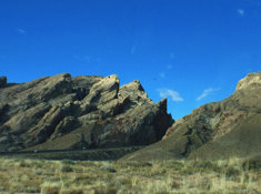
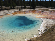
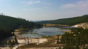
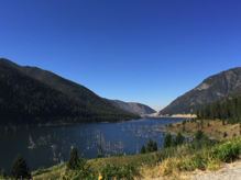
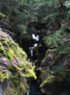
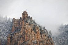
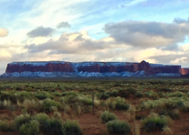
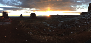
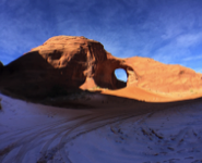
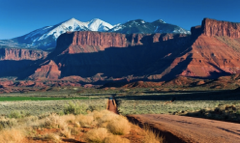
My (new) GPS showed I only had about half an hour left to my hotel when it was making me turn on this horribly rough dirt road. My fault—I forgot to set dirt roads as an avoidance in the navigation settings. I started freaking out because it showed me on this road for 20 miles, and I had no idea how far it would be unpaved. I was more freaked out at the prospect of getting a flat tire on this isolated road. But just when my anxiety was about to max out, I got the view of a lifetime (second photo below).
And the rough road ended only a quarter mile after that. My best friend reminded me of that Robert Frost quote, “I took the road less traveled, and that has made all the difference.” I made it to my motel a short time later, and although I was disappointed that my rather Spartan (but clean) room did not have a roll-in shower as stated, it had a fold down bench that I felt I could work with. I was just so happy to be out of the car that I would settle for a sponge bath!
DAY TWO - Grand Teton
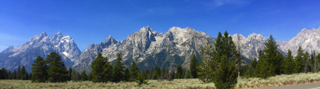
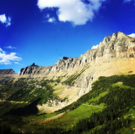
After going to bed early and getting 11 hours of sleep (thank youuuuu, blackout curtains), I was ready to head out to Grand Teton National Park. The drive east from Victor, ID took about 45 minutes, and the northbound turn took me past Teton Village and the ski resort of Jackson Hole. Being a former [intermediate] skier, it's always odd for me to see ski slopes carved out of the tree line on a mountain without the snow. Anyway, after several miles of narrow and windy road, I finally entered the "meaty" portion of the park.
I should mention that Grand Teton isn't huge by any means, as national parks go. The main visual draw is the dozen or so major peaks of the Teton range to the west. There's a 45 mph loop around the park that only takes 1-2 hours to complete, depending on stops. I saw a ton of people on bicycles, and there's a beautiful system of lakes and rivers at the base of the peaks that are popular with kayakers (I imagine). I took at least a million photos of the peaks because they're just so stunning. I ended up staying in the car because I didn't come across anything that seemed worth the effort to haul my scooter out of the trunk.
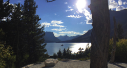
The east side of the park had a more mellow landscape, but I did get to see a huge herd of bison! Sadly I had nowhere safe to stop and take a picture. The view of the Teton range was more distant, but still beautiful with the grasses in the foreground.
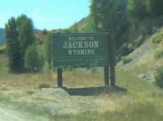
As I left the park, my original intention was to loop back to Teton Village for a bite to eat and maybe some shopping before heading back to my hotel. I had to drive through the town of Jackson (interchangeable with Jackson Hole, it seems) before heading back west, but I ended up staying there. It is designed to look like an Old West town for skiers in the winter and outdoor enthusiasts in the summer--with all the touristy trappings that entails. I had to check it out.
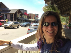
After miraculously finding a decent place to park, I stopped to grab some lunch and enjoyed a delicious bison burger. After that, I headed out to see the town. To say Jackson, WY is not wheelchair friendly is an understatement. ALL the sidewalks are wooden, so it's a really rough ride. At least half the shops and restaurants have a step to go inside. The curb drops at intersections are really rough. And some sidewalks that start with ramps to go up end up in stairs to go down. I was able to eat and do some shopping, but after all the turning around I had to do, the crazy late summer crowd, and the disappointment of not being able to enter so many stores, I decided it was time to head back to my hotel for more Olympics on TV and another good night's sleep.
DAY THREE - Yellowstone
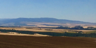
After another good night's sleep, I started the two-hour drive north from Victor, ID to the west entrance of Yellowstone National Park. It was a mellow drive, and while I didn't have massive mountains nearby to keep me company, I (once again) had plenty of wheat. Honestly, I've never seen anything like these wheat fields. They go on forever, as far as the eye can see. And someone has to harvest all that acreage! It really is beautiful; a patchwork of amber mixed in with some green crops and recently tilled plots that make the rolling hills look like a big quilt. It was absolutely beautiful.
Before I entered Yellowstone at the end of my drive, I didn't really know what to expect. I mean, I knew Old Faithful was in there somewhere, and maybe some mountains, rivers, and large mammals. But I'm glad I had few expectations because it makes every discovery a surprise.
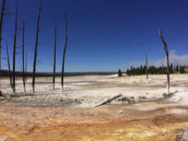
The main loop road through Yellowstone is a figure eight, and since I had already driven two hours, my plan was just to do the southern loop before heading to my hotel. The western part of the southern loop is jam packed with great sights, and I had to be choosy about where to stop and make the effort of unloading (and later reloading) my scooter. My first stop was the Fountain Paint Pots. This was my first exposure to how incredibly alien the scenery in Yellowstone could become. But before I get to that, let me explain a bit more about the park.
Yellowstone essentially sits on top of a huge supervolcano. It's the result of a collapsed caldera from God knows how many hundreds of millions of years ago, so many miles down there's a river of molten rock that fuels constant geothermal activity across the park. There are constant reminders of this feature because there is steam billowing from what seems like every square inch of the park's almost 3,500 square miles. There are geysers large and small spewing boiling water either constantly or periodically, fumaroles (which are steaming vents), and "ponds" that are filled with acidic and sulphuric water and are also constantly steaming. It lends an otherworldly characteristic to a park that might otherwise be lumped into the "alpine fir and mountain" category.
So going into the FPP area, I was totally blown away by the rich glacial blue of the "ponds" and the corresponding rust orange of the bacteria growing around them. The mineral flats are a salty bleached white in the midst of the alpine green of the lodgepole trees and the amber of the surrounding plains. The FPP are partly named because they have a "pot" with bubbling mud that looks like (and probably is a lot like) grayish clay. There is also a good-sized geyser just off the (accessible) wood walkway that wraps around all the things to see there.
After spending a good hour at this site (and getting help from some nice strangers from NC with putting my scooter in the car), it was time to head to Old Faithful! I stopped at a few pullouts on the way and drove through some crowded parking lots, and unfortunately had to pass up an excursion at the Midway Geysers and prismatic springs to save some energy.
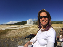
My arrival at Old Faithful was a bit of a shock. I expected it to be like most of the other sites I had been to or passed by so far--a large parking lot with a lot of people milling around. I had no idea that basically a small town had been constructed all the way around this one geyser. There were two hotels, a large and very modern visitors' center with a theater, a gas station, several large shops, and at least one restaurant.
As for Old Faithful itself...well, the name is a bit misleading. The time between eruptions can vary from every 40 to every 126 minutes. When they do predict a time for the next eruption, it comes with a plus-or-minus 10 minute caveat. The initial eruption is actually pretty impressive. I can't estimate how high (I'm sure you can look it up), but it's at least 50-60 feet. However, that height is only maintained for 30 seconds or so. After that it drops to about 10 feet, then quits after about a minute--even though I was told twice the eruptions last between 3-5 minutes. Oh, well.
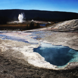
The real treat in the Old Faithful area actually wasn't that geyser itself; it was Geyser Hill above it and the mile-long loop that circled around at least a dozen smaller geysers, fumaroles, and ponds. Many of these erupted while I was right in front of them! The colors were incredible, and the steam from geysers was absolutely everywhere. I spent probably three hours total just in this area, and it was time well spent. This wrapped up my first day in Yellowstone, and I was already looking forward to what the next day would have in store.
DAY FOUR - Yellowstone
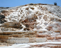
The ride into the park was definitely hazy due to smoke from local fires, but the views were good enough for decent photos. I pulled out at a few stops to take photos from my car on my way to Mammoth Springs; this route was definitely less scenic and interesting than the southwest side. However, the steaming springs in Mammoth and just south of it are some of the most fascinating geological formations I've ever seen. A combination of mineral white and rust orange, they're a series of layered terraces with water flowing over them from the bubbling/steaming springs at the top of the plateau. I'm doing a terrible job describing it, so hopefully these photos will help a little bit.
Getting to the springs was going to be a no-go. The walkways are all wooden ramps and stairs like a scaffold wrapped all around the formations. The parking lot was crazy, so I did the best I could from as close as I could get.
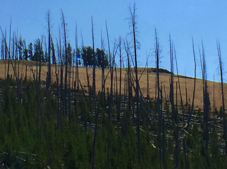
After Mammoth, my next planned stop was Canyon Village and the loops along the "Grand Canyon of Yellowstone." It was a long drive, and mostly unremarkable. What is fascinating about Yellowstone is how quickly the scenery changes from alpine to high desert to grassy plain and back again. On this stretch, I saw some very stark reminders of the 1988 fire that destroyed almost 800,000 acres and caused the park to close for the first time in its history. A full 36 percent of Yellowstone was affected by the fire, which was made obvious by the millions of dead lodgepole pines strewn like match sticks across mountainsides. It was also strange to see the spires of burned pines among the much smaller new growth of pines below them. Fire is necessary in forests; pine cones can't spit out their seeds until the heat causes them to crack open. However, the 1988 fires were unprecedented and disastrous; the evidence of that was everywhere, as were signs of life and regeneration.
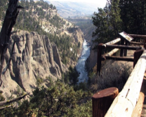
My next stop was pretty amazing. I've been to the Grand Canyon and canyonlands across Arizona and Utah so this one wasn't earth shattering, but it was still impressive. It has a double waterfall (upper and lower), then a canyon-length view at the end of the loop. It was crowded at every lookout and I was tired after a long day of driving, so once again I did the best I could photo-wise.
The drive back was pleasant; no more smoke, clear skies, winding roads, and peaceful plains. Overall, I saw one herd of bison, four solo bison in fields, one male elk wading in a river, and two female elk(s?) dining roadside. Not bad, considering I spent most of the time in my car and in busy places. The best times for wildlife viewing are at dawn and dusk--two times I was not in the park--and the best places on hikes, for which I'm not exactly suited. Hey, I was just happy to see any animals in their natural habitat and not in a zoo!

DAY FIVE - Montana
I left West Yellowstone under a thick layer of smoke; the fires in and around the park are only getting worse, so I'm glad I left when I did. However, no one was going the full 70mph speed limit; I could only get up to 40mph safely because of the dramatically reduced visibility. It actually felt like I was driving in a really bad Florida thunderstorm. Add to that the constant warnings of wildlife crossing the road and you find yourself on high road alert for long stretches, and that gets tiring.
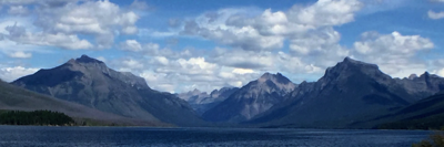
After about an hour or so, the smoky haze finally lifted and revealed clear blue skies. I thought this 7-8 hour drive north to Whitefish might be uneventful and maybe boring, but I was wrong on both counts. The scenery in western Montana is some of the most beautiful I've ever seen in the United States. I entered a lush green mountain valley with a lake and river at the bottom.
And deer crossing warnings. Not long after seeing the sign, I had to come to a screeching halt because an 8-point buck decided something looked better on the other side of the road. Fortunately, the driver behind me was paying attention and I didn't get rear ended. I had a mild heart attack; the deer didn't even flinch. After I recovered, I kept driving down this stunning riverside road and was treated to some amazing views. Then came the bighorn sheep crossing warning. And the falling rocks warning. What sealed the deal for me was the sign pointing to a geologic sit called "Night of Terror"; I was convinced Montana was trying to kill me, lol.
Anyway, I made it through this gauntlet and spent the next few hours driving through golden valleys, along sapphire rivers, and next to rocky foothills. It became pretty obvious to me rather quickly that three things are huge in Montana: hunting, fishing (particularly fly fishing), and lumber. Weyerhauser has a huge facility not far from my hotel, and I must have past several dozen trucks carrying hundreds of logs each. If you've ever seen the amazing movie A River Runs Through It (one of my all-time favorites), it was filmed in the parts of Montana I drove through today. I can see why this is such a huge draw for outdoorsy people looking for peace and tranquility.
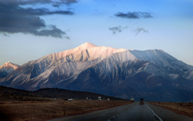
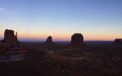
The road became more windy about an hour south of Whitefish, and cruise control was no longer an option. I was tunneled in by very tall pines on both sides, and I sped past a sign that said "scenic view." I wasn't planning on stopping until I got a millisecond glimpse of what I was going to pass up. I had to turn around and stop. Then I got this...my first on-the-ground glimpse of the Canadian Rockies.

DAY SIX - Glacier
I woke up pretty excited on the last day of my solo road trip since Glacier National Park is the very reason I came here in the first place. I had seen many photos online, so I had a little bit of an expectation of what I would see. The day promised to be beautiful; a few clouds with a very small chance of sprinkles in the afternoon, and more clear skies. I was scheduled for a 7-hour tour with Red Bus Tours at 1:30 PM in an accessible van. I decided to head to the visitor center a bit early to look around before my tour.
When I arrived at the visitor center, my bus driver was already there. Red Bus Tours added two accessible vans to their fleet a couple of years ago, and I expected to have at least 10 other people on the bus with me. But this was going to be a private tour! The lady from the company said that even if there's only one person booked for a tour, they still go. I couldn't wait! Except I had to wait for a few minutes. I checked the weather, and while it was going to be cool at upper altitudes, I expected to be inside a climate controlled bus. Well, the accessible van had huge windows made of clear tarps that were all rolled up. I ended up having to go inside the visitor center and buy a long sleeved shirt and thick sweatshirt in the gift shop since all of my layers and jackets were back in the hotel room. Oh, well! New souvenirs.
Soon we were on our way. Glacier National Park is relatively big, but there's one main road that traverses the center of the park called Going to the Sun Road. Some parts of this road start closing as early as the middle of September due to snowfall, which is why I scheduled my trip for the end of August. But one of the biggest surprises of this park was our first stop, which was a 1 mile loop through, wait for it… A rain forest. Rod, my tour guide, was very very knowledgeable about the different plants and animals throughout the park, so I got an amazing education on Cedars, Hemlock, in Cottonwood, which are the three main trees growing in the park. In this area, there was so much canopy and plenty of running water. It was very damp, and there were mosses and mushrooms everywhere. It was the last thing I expected in a national park with the word glacier in its title.
After spending a considerable amount of time in this area, we got back on the road, which got loopy very quickly. We started going up in altitude and the wind started getting chilly. But the views… I can't say enough about how awe-inspiring the views are. I became familiar with the effects of glaciers on land as they move through terrain and scoop out valleys while I was in Alaska. Most of the road has a sheer drop on the right side, so it's easy to see the U-shaped valleys and the impact of glacier movement in the park. However, the glaciers in this park are relatively small, even though there are 25 of them. We were able to get a glimpse of one in the distance.
Halfway through the tour, we stopped at a little restaurant where I was able to have lunch. Much to my delight, when I came out of the restaurant to reboard the van, the clouds had disappeared and the sun was out! This made for much better pictures on the return trip. Wanting to enjoy the ride, I had to ask Rod to lower the window tarps so I could experience some warmth. Although if I wanted to take any pictures after this point, I knew I was going to have some plastic in between the view and my camera phone, it was well worth it for some comfort!
After I got back to my hotel room, I went straight to bed since I had to wake up at 4 AM for a very early flight home. I can't tell you how huge my sense of accomplishment was. This was a physically difficult trip; much more so than my canyonlands trip last November. I was extremely fortunate that I had someone to help me put my scooter in my car all but two times this entire trip; however, those two times were very anxiety inducing and difficult. I'm sorry to say that this will be my last solo road trip, but I've pretty much knocked off all the bucket list road trip items. There are still some places in the United States I want to see, but I should be able to do them with either an accessible tour company or just by being based out of one city.
Solo Road Trip: AZ and UT Canyonlands
DAY ONE - Sedona
This isn't my first solo trip to this area. About 15 years ago, I went to Sedona and the Grand Canyon on a solo trip and had a blast. However, I was very able-bodied back then. For this trip, I had to plan more carefully, and not just when it came to reserving handicap accessible rooms. I'll be driving through very remote areas on my own, so safety precautions are a must. My first accoutrement was a Spot GPS device and extra batteries. These are used mostly by hikers and bikers who travel into canyons and places with no cell phone reception. It allows the user to send an "I'm OK" message to cell phones and emails, and can also request emergency assistance using GPS satellites.
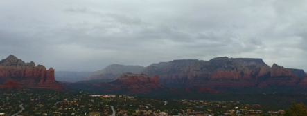
I knew the weather was going to be spotty today, but I was hoping for at least a little bit of sun. I got ten minutes worth all in all, but it was better then nothing. The endless on-and-off rain started on my way to Sedona, but there was enough dry time for me to get some good photos from the car. My first destination was the Upper Loop Road through Red Rocks State Park. It's not long, but offers spectacular views of the red rock formations Sedona is so well-known for. And the leaves!! The fall color change is happening everywhere here, which you wouldn't expect since the assumption is Sedona is just as dry a desert as the rest of Arizona (which is another misconception). Because it takes longer for things to turn colder here, the trees are really in peak color right now and almost exclusively yellow. It's gorgeous!
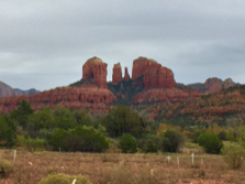
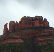
Then it was off to Sedona proper, and drives to some of the famous rock formations that are said to be vortexes (Sedonans don't call them vortices, so I'm not flaking on my grammar) for energies rising up from the earth. If you've never heard of Sedona or been here, it's an ENORMOUS enclave and attraction for the more spiritually minded. I was able to see Cathedral Rock, Bell Rock, and Chimney Rock. Sadly, Airport Mesa--the best sunset view in town--was mostly a bust due to the rain. However, I was soon rewarded during my final loop visit through Boynton Canyon. The sun actually came out for ten minutes! And I got a rainbow! Very cool indeed.
DAY TWO - Northern Arizona
It's snowy and windy today--which I totally expected and was prepared for, but now I have to drive for five hours in it through very remote parts of northern Arizona. After my massage, I checked out, loaded up the car, and...the sun came out!! So of course I had to take advantage and take a few more pictures in Sedona before heading north ;).
After that, I had to make the decision of playing it safe by taking the interstate, or hoping the snow would stay light and fluffy (i.e. not slippery/icy) and take scenic route 89A through Oak Creek Canyon. I took a chance and decided on the latter; and BOY, and I ever glad I did. That was frankly the most awe-inspiring 20 miles I've ever driven. Oak Creek is a long, windy, and narrow canyon with a river at the bottom, a pine forest in the middle, and towering red rock cliffs climbing to the top. Because of the snow and fog, the cliffs were partly shrouded and I felt like I was being watched by gargantuan ghosts the whole way. Fall just came to Sedona, so at least half of the trees were a very bright golden yellow, forming a canopy over my car.
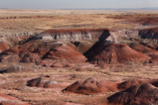
By the time I topped out at the end of the canyon, the snow was falling more heavily and the roads were very wet. Fortunately, I made it to Flagstaff without incident, where...the sun came out. Again. Yay!!! The first hour north was pretty boring, but soon the surprises began. It was one of those situations where every 15 minutes I would crest a large hill and see a completely different landscape than the one I just left...along with a different form of precipitation. First I was reintroduced to the Painted Desert, which I first visited during my solo Grand Canyon trip in 2000. The colors are pastels and much more subdued than the bright, deep reds and greens of Sedona, but gorgeous and inspiring nonetheless. Again, I stole this photo because I couldn't stop anywhere. After that, I crested a hill and saw the place where they had to have filmed 'The Martian,' I kid you not. For a solid 20 minutes you would have had to work VERY hard to convince me I wasn't on Mars. It was completely surreal, and I deeply regret not being able to stop and photograph it.
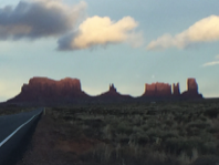
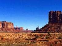
But at last, after sun, snow, rain, snow, sun, snow, and rain came...Monument Valley. And as luck would have it, I was arriving about half an hour before sunset. I promise you there are a LOT of people cursing the woman in the silver Nissan Altima because I pulled over at least every ten minutes to take another photo. #sorrynotsorry. There were a few puffy clouds in the sky and the angle of the setting sun made the scattered spires before the entrance to the actual Navajo Park look exactly like they do in the movies...but better. Then add the fine layer of snow and...well, here are some pictures :).
Tomorrow my plan is to hire a Navajo guide with a 4x4 vehicle and let him educate me while driving me around the park to get some great photos. Technically, anyone can drive the 17-mile loop through the park, but it's packed dirt and tends to get nasty when it's wet. We picked up a couple of inches of snow tonight, and that crap is going to be melting all morning--yuck :(. My Altima will be toast in that mess, and my guide will be pleased that I won't even want to get out of the car. I'm also excited to be woken up by the sun. I'm staying at The View Hotel--the only hotel inside the park (Navajo run, of course) and aptly named because every single room has its sliding doors and patio facing the park...with three huge spires only a few hundred yards away. Yeah...it's going to be an epic sunrise :).
DAY THREE - Monument Valley
Vacations are designed for sleeping in, right? I'm all for that, but last night I intentionally left the curtains wide open so I could wake up at first light. Why on earth would I do something so insane, you ask?? Take a look at the view in the first photo below.
Somehow I lucked out and got a room reservation for two nights at the most in-demand hotel anywhere near Monument Valley. I suspect the demand isn't only a result of it being the only hotel in the Park and the only one for 23 miles. Anyway, I sat on my balcony for probably 20 minutes just taking a photo of the view that changed every 2-3 minutes, freezing my behind off (my weather app said 26˚ with a "feels like" of 7˚) the whole time. There were about 20 people chattering and oooh-ing and ahhh-ing on the restaurant terrace while hopping about to stay warm, aiming their cameras and phones at the awe-inspiring scenery. This was a completely apropos start to my day.
I wandered over to the attached restaurant for breakfast, and for the second meal in a row I found myself wondering, Where are all the Americans?? Last night I was in Korea and this morning I was in France. Well, as I was watching a CBS documentary today during lunch about Monument Valley, I learned that of the roughly 480,000 annual visitors to Monument Valley, 70 percent of them are from foreign countries. My jaw just dropped when I heard that statistic. There have been like three dozen westerns and a gazillion more movies filmed here; I figured this would be a huge attraction for Americans over foreigners, especially those doing an Arizona-Utah canyon route like myself. But nope; I feel like I'm in Europe again, perking up whenever I hear someone speaking English. Weird.
Anyway, after breakfast I bundled up (the 20 mph winds make it [insert expletive here] cold) and headed to the back of the parking lot to find myself a Navajo guide. Not only was I nervous about braving wet clay roads--I wanted to see every square inch of the park that I could, and you can only do that with a paid guide. I explained my situation to Matthew--I just needed space for my electric scooter in his trunk and help getting into his Chevy Suburban. I wouldn't be getting out for any reason, but I would want to stop many times to take photos. I also would be asking an annoying amount of questions because I wanted to know everything he could tell me about the Valley's history, people, plants, animals, weather, geology...you get the picture. He was down with it, so off we went.
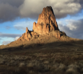
Honestly, of all the places I've been in the United States and around the world, Monument Valley is easily the most impressive thing I've ever seen. You don't realize how ginormous the spires and buttes and mesas are until you see the birds flying next to them like gnats or the cars driving below them like ants. They're made of sandstone, which has cleaved away and been worn down by water (hundreds of millions of years ago) and wind, which results in red sand dunes (and clay mud) towards the back of the valley. The Anasazi lived here from about 200-1300AD, so I was able to see a panel of their markings. That was chilling, since no one really knows for sure why the Anasazi pretty much just up and left in 1300AD.
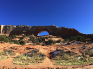
I knew from pictures and movies that Monument Valley was known for its spires and buttes. But I had NO idea what was waiting for me on the other side of the Valley--much of it only accessible with a Navajo guide. We saw natural arches and "windows" in the huge sandstone formations, running water that emerges from springs ATOP the cliffs, sand dunes, and even a small pack of coyotes making a rare appearance in full daylight. There are even a few Navajo families who call the Park home, and we drove by their very modest dwellings a couple of times--some trailers, many modern and traditional hogans, and even sweat lodges. There is no electricity or running water to supply these homes, so they have outhouses and have to haul in fresh water since the natural springs don't provide enough to supply them.
After three hours of driving (in some cases, wrestling with the road), we headed back. I had a nice lunch, did some shopping in the gift shop, and spent some time on my laptop working on this post and checking in on the world while enjoying the very dynamic view through the hotel lobby windows. At around 4pm, the hour-long daily spectacle known as "sunset" in the valley began, which of course meant it was time for me to bundle up once again and stare slack-jawed at some ancient rock formations.
Fortunately I was able to get some great shots from my hotel room balcony once again because I did NOT want to go outside. I did, and if it wasn't for the spectacular sunset I was rewarded with, I would have regretted it. The temperature itself wasn't that bad; maybe low 40s. But the wind was punishing, roughly around 20mph with at least 30mph gusts. Wind chill anyone?? But that didn't stop a throng of people (mostly speaking languages I didn't understand) from heading to the terrace for photos.But after about ten minutes, I just couldn't take the cold and had to go inside. The buttes behind the hotel were already fully in shadow, so I figured the show was over anyway. I started taking the lenses off my iPhone, taking off my jacket, charging my selfie stick, and editing my photos from the day. I exchanged a few messages with my best friend, and sent a few emails. I happened to look up in the direction of the balcony only because a bird flew by and caught my attention. Then I nearly peed my pants when I saw the view and started panicking to get my phone camera ready. Monument Valley wasn't done with me yet. In about the span of 20 minutes, the view went from the cobalt blue sky and copper oranges you see above to baby blues, pinks, and lavenders. Purely. Amazing.
DAY FOUR - Four Corners and Utah
Fortunately yesterday's brutal winds died down and the temperature rose a bit to make things much more comfortable. My plan after leaving Monument Valley was to visit Valley of the Gods about 30 miles to the northeast, which is supposedly a mini/compact version of the former. Unfortunately, as soon as I pulled into the packed-clay loop off the highway, I read a sign that said "Wet roads are impassable," or something along those lines. Then I looked in front of me at the wash that was...wet. Honestly, it was only a couple of puddles, but I had no idea how deep they were. And I was in a rental sedan. Nonononononono.
So on I went towards Four Corners Monument. I had read in some online guide that the area surrounding the monument was isolated and bleak. It is definitely isolated, but I actually enjoyed the scenery; definitely a change from what I had been seeing the previous two days. Lots of rolling grassy hills, with scattered rock outcroppings and the snow-capped La Sal mountains in the distance to the north.
I knew the monument itself wasn't going to be much to behold, but it was actually quite nice. It was a small concrete plaza with the metal circular marker in the center. There were about four rows of circular amphitheater-style seating, for what is anyone's guess. This place is in the middle of nowhere and I can't imagine what would draw so many people there that those benches would be filled. But, whatever. There were about a dozen or so people milling around, which is a dozen more people than I expected to be out here in November. This is NOT a destination attraction, lol...people come here like me because it's sort of on the way to...somewhere else :). Anyway, I went to the marker and took the requisite photo of my feet in four states at once. I bought a little souvenir from one of the 40 or so vendor stalls that was actually occupied, and then I was on my way to Moab.
The roughly 2 ½ hour jaunt between Four Corners and Moab started out pretty blah. However, after an hour I was rewarded with one of those surprise-over-the-summit moments. One of the strangest juxtapositions I've ever seen was laid out before me--red rock canyons in the foreground, and huge snow-capped mountains with pine forest creeping up the sides in the background. I didn't take this photo (once again, no safe place to stop for a photo, but it will give you an idea of my view for the next hour until I pulled into Moab. I was also able to pull over and take a picture of this gorgeous arch.
I'll admit, I knew very little about Moab, Utah before arriving here today. I only knew it was located in the Utah canyonlands, was very scenic, and was a mecca for mountain bikers. Wanting to learn everything I could about each place I visited, I discovered that Moab was actually considered the "uranium capital of the world" in the 1950s after the mineral was discovered flourishing in mines here. Due to the "popularity" of nuclear weapons at the time and the Cold War, the town boomed and the population grew by 500 percent in a very short time. After the uranium mines closed in the 1980s, everyone left and much of the town shuttered up. Now it makes most of its money from tourism.

DAY FIVE - Canyonlands and Arches
Today was "Explore Moab" day--or at least the general Moab area. My plan was to hit two national parks and one state park before sunset, and since all three are within 30 miles of each other, this turned out to be pretty easy.
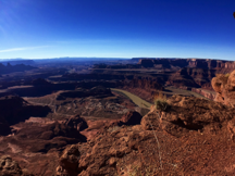
First up was Dead Horse Point State Park, a recommendation from a friend who used to live near Salt Lake City and is familiar with all things Utah. The park itself is pretty small, and is only a few miles before you get to the entrance of Canyonlands National Park--my second destination, so it was already on the way. There are a few camping sites there, but the main draw of the park (from what I can gather) is the AMAZING view of the canyon at the end of the road. It was only a few miles' drive to get there, and the entire large viewing area had a lot of paved sidewalks that covered roughly 180˚ of viewing area.
I really hate getting out of my car because taking the scooter out, putting it together, then taking it apart and putting it back into a sedan trunk with a lip (as opposed to my crossover with a flat trunk entry) can be a real pain in the butt. But canyons are a different animal when it comes to a "windshield tour" that I was engaged in. Unlike Monument Valley where all the sights shoot up a thousand feet above the ground, canyons are, well...sunk. If I wanted to enjoy the view, I needed to get out of the car. And OMG was it worth it...
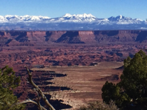
I visited the Grand Canyon about 15 years ago, and I had never (obviously) seen anything so overwhelming. This canyon came pretty darn close, if only because of the snow-capped mountains in the background that presented such a strange and sharp contrast. The Colorado River snaked very slowly along the bottom, which gave the impression that this canyon was the Grand's little brother.
From Dead Horse Point I drove next door to Canyonlands National Park--which is basically a much larger version of the state park. Canyonlands actually has four different sectors, but they're not connected so you have to enter each part of the park through entrances that are dozens of miles apart. The entrance I was using, called Islands in the Sky, has the longest driving loop (I think two entrances are only for campers and serious hikers). Fortunately, the lookout points and vehicle pullouts were abundant, and the views were clear enough of the canyons below that I didn't have to get out of my car--which is really saying something because my selfie stick/monopod that I was using to elevate my phone for pictures died shortly after I entered the park.
The road that goes through Canyonlands is almost like an island (thus the name, I suppose) surrounded on three sides by terraced canyons as far as the eye can see. The colors range from brown and deep red to light orange and tan. The tops of the canyons, like the road I was on, does not betray what lies below. It's all straw-colored grasses and green shrubs, with the occasional juniper tree dotting the landscape. There are some rocky outcroppings here and there, but the surface-level landscape is more or less unremarkable. That's what makes the canyon views, in my opinion, so jarring and breathtaking.
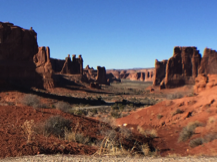
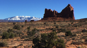
From there it was a 24-mile drive to Route 191, and a short 4-mile jaunt to Arches National Park. Let me start off by saying Arches was NOT what I expected. I got the park guide while going through the entrance gate, and I learned that it's one of the world's largest collections of natural arches. These arches are formed in sandstone sitting on top of a huge shifting salt flat. Over the millenia, rain and wind and ice have done their work with the porous sandstone to form these arches. I expected to see a lot of them, given that the guides say there are plenty which are visible from the road. Two words, people: False and Advertising. I think I saw maybe five arches, and I drove every inch of that park that was drivable. It turns out you have to take hikes/walks of varying lengths and difficulty to see most of the arches.
But you know what? It didn't matter one bit. Because Arches gave me even more surprises--the biggest variety of geological formations, terrain, and scenery that I've ever seen in the span of a short 15-mile drive. The spires and buttes are made of two different types of sandstone, so the color is split between the typical deep red and a light tan. Some of them looked like Monument Valley-type formations, and others looked like gigantic versions of my kids' playdoh creations. The park has petrified sand dunes. Huh??? It has gray/brown/boring salt flats across the street from huge red spires in the forefront with the La Sal mountains in the background. Whaaa??? Disconcerting to say the least, and my head--and steering wheel--were on a swivel trying to capture it all in my brain's and iPhone's memory.
DAY SIX - Utah
The roughly 150-mile stretch of I-70 between Green River and Salina, Utah contains some of the most breathtaking scenery you'll ever see. Around mile marker 129 you'll find something called the San Rafael Swell, where hundreds of millions of years ago, geological forces pushed up a great mass of earth. Over the eons, parts of the earth came crashing back down onto the salt flats and created these canyons and buttes and outcroppings.
In that area there is also a 30 mile-long wall called the San Rafael Reef. From what I was able to read at one of the scenic overlooks, Spanish explorers took great care to go around this wall because it was just impassable. Then finally in 1970, with the help of generous amounts of TNT, civil engineers were able to blast a narrow passage through the reef for I-70 to pass through. Just on the other side of that passage, I was able to get a decent photo of the Swell.
Although I wasn't able to get off the paved/beaten track to see them, I was driving right through the middle of dinosaur territory. There are petrified dinosaur tracks all over the place in this area, as well as petroglyphs created by the Fremont indian tribes and the Snake Clans. Even more scenic were the Coal Cliffs to the north, striped in shades of copper, pink, and tan.
As I approached Salina and the turn to the north, I entered Fishlake National Forest and another abrupt change of scenery and weather. I was surrounded by pine forests and snow-covered mountains--many well over 11,000 feet in elevation, and the mist was releasing a fine drizzle. All of this lifted on the other side of the range when I turned to the north in Salina. The sun came out and I was treated to views of the valley: snow-blanketed open fields to my left, low foothills to the west, and majestic mountains to the east (the San Pitch range) and north--my first hint of the upcoming Wasatch Range outside of Salt Lake City.
It's fitting that Mt. Nebo--the highest peak in the Wasatch Mountains at just under 12,000 feet--was my send-off, reminding me of how small I am, and how small we all are, in the grand scheme of things. During a five-hour drive and a four-hour flight, you have a LOT of time to reflect, think, and process. What started out as a bucket-list trip ended up being in large part a spiritual journey. I gained so much understanding and peace being out in the middle of nowhere by myself, and I left a lot of things behind. I left my guilt in a darkened room filled with sage smoke in Sedona. I literally buried my sadness--and hope--in the depths of Monument Valley and prayed the giants above and around me would keep their watch over me. I broke off a piece of my heart and left it peacefully in Moab, knowing I would be okay if it stayed there forever.
Six days, four states, 432 pictures, 1132 miles of driving, and one electric scooter. There were times when I went almost an hour without seeing another vehicle, and even though I've never been so physically isolated in my life, I never once felt alone or lonely. I was never scared or worried. Some people will call me reckless for embarking on this trip by myself when I can barely walk, let alone physically manage in a major crisis. Others will think I'm brave for even attempting this journey. I felt neither of those things.
What I did feel was joy, peace, and contentment. Many tears flowed during this trip, but not from sadness. It was from the release that comes from true healing, and letting go of toxic emotions and things in your life that make you unhappy. I'm not saying you need to crawl into a cave for a week to do this--hell, my idea of "roughing it" is a night in a Motel 6--but there's a lot to be said for immersing yourself, and only yourself, among some of the most overwhelming things the Earth has to offer and pondering just where you fit into all of it. I'm so lucky that having MS didn't prevent me from having this experience. And if *I* can do this alone, so can any able-bodied person. You have no freakin' clue how much time you have left. Figure out what you need to let go, where you need to be to do it, and just. Freaking. Do it. There's no time like the present ;).